TS 10th Class Social Important Questions 5th Lesson Indian Rivers and Water Resources
1 Mark Question
Question 1.
What are the tributaries of the Indus river?
Answer:
The tributaries of the Indus river are the Jhelurn, the Chenab, the Ravi, the Beas, and the Sutlej
Question 2.
Name any two tributaries of river Indus?
Answer:
The Jhelum, the Chenab, the Ravi, the Beas, the Sutlej
Question 3.
What the two branches of southwest monsoons which bring rains to india?
Answer:
The two branches of south-west monsoons which bring rains to India are
- The Arabian sea branch
- The Bay of Bengal branch
- Observe the map given and answer the questions 4 and 5
Question 4.
Name the two rivers that flow into Arabian sea?
Answer:
The rivers that flow into Arabian sea are
- Sabarmati
- Mahi
- Narmada
- Tapati
Question 5.
Through which states, the river Tungabhadra flows?
Answer:
River Thungabhadra flows through Karnataka, Telangana, and Andhra Pradesh
Question 6.
What are the three physiographic units of the drainage of India?
Answer:
- The Himalayas
- The Peninsular Plateau and
- The Indo-Gangetic plain
Question 7.
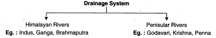
Divide the Indian drainage system on the basis o? its origin?
Answer:
- The Himalayan rivers
- The Peninsular rivers
Question 8.
Name the three Himalayan rivers?
Answer:
- The Indus
- The Ganges
- The Brahmaputra
Question 9.
Which rivers are perennial? Write the reason?
Answer:
The Himalayan rivers are perennial. This rs because the rivers are supplied on rainfall as
well as the melting snow
Question 10.
Where does the Indus originate? What is its route?
Answer:
The Indus originates in the northern slopes of the Kailash range in Tibet near lake Manasarovar. It follows a north-westerly course through Tibet
Question 11.
Where does the Indus enter India?
Answer:
It enters Indian territory in Jammu and Kashmir
Question 12.
What do the water resources require?
Answer:
The water resources require both collective action at the local level and appropriate laws and policies at the state and national level
Question 13.
What are the two sources of the Ganga system?
Answer:
Gangotri (Bhagirathi) and Alakananda are the two sources of the Ganga system
Question 14.
What is the significance of Devaprayag?
Answer:
Bhagirathi and Alakananda join at Oevaprayag to form the Ganga
Question 15.
Where does the Brahmaputra rise?
Answer:
Tire Brahmaputra in Tibet rises from the snout of the Chemayungdung glacier of the Kailash range near Manasarovar
Question 16.
Where does the Brahmaputra enter India?
Answer:
The Brahmaputra enters in a great loop southwest through Arunachal Pradesh In India, first as the Siang and then as the Dihang
Question 17.
What are the two tributaries of the Brahnraputra?
Answer:
The Dibang and the Loliit are the two tributaries of the Brahmaputra
Question 18.
Where do the peninsular rivers originate?
Answer:
The peninsular rivers the Krishna, the Godavari, and the Cauven originate in the Western Ghats. The Mahanadi originates in the Vindhya and Satpura ranges
Question 19.
Which lathe largest peninsular river system?
Answer:
The Godavan is the largest peninsular river system
Question 20.
What is the source of the river Godavari?
Answer:
The source of the Godavaris n the Thambak plateau near Nasik in Maharashtra and dacharges its water into the Bay of Bengal
Question 21.
Write the inflow as a formula?
Answer:
inflow = Precipitation + Surface flow + Groundwater flow
Question 22.
What is called evaporation?
Answer:
The turning of water into vapour is called evaporation
Question 23.
What is called transpiration?
Answer:
Living things give off water into the atmosphere through their breathing process, this is
called transpiration
Question 24.
What is called evapotranspiration?
Answer:
The total amount of water added to the atmosphere from both evaporation and transpiration is called evapotranspiration
Question 25.
When would the surface flow Increase?
Answer:
The surface flow would increase during the monsoon months
Question 26.
How does the water reach the root zone of crops?
Answer:
Water reaches the root zone of crops either through rainfall or some process of irrigation
Question 27.
Which kind of water is vital need?
Answer:
Water used for drinking, cooking, washing, cleaning, and for animals is vital need
Question 28.
Name the surface storages?
Answer:
Tanks, ponds, lakes, etc. are the surface storages
Question 29.
What is the question that we face today about the groundwater?
Answer:
The question that we face today is the depletion of groundwater storages and tendency not to care about the availability for future generations
Question 30.
What are the two parts of the Tungabhadra basin?
(OR)
Classify the Tungabhadra river basin.
Answer:
The Tungabhadra basin has two parts:
- The upper and middle catchments in Kamataka and
- The lower portion of the catchment in Telangana and Andhra Pradesh
Question 31.
Which water is available to us?
Answer:
The annual flows and stocks that recharge welts and tubewells is the water that is available for us
Question 32.
When can the mining water be done?
Answer:
The mining water can be done only in extreme drought situations and replenished in good rainfall years
Question 33.
How are the low portions of the Tungabhadra basin characterised in Andhra Pradesh?
Answer:
They are characterized by low rainfall and drought
Question 34.
What is the result of encroachment of public land for cultivation?
Answer:
It results in more land being brought under cultivation at the expense of tree cover
Question 35.
What is the result of rampant felling of trees and mining activity?
Answer:
Rampant felling of trees and mining activity is resulting in forest degradation. along with the destruction of the habitat of highly threatened flora and fauna
Question 36.
Why did the Tungabhadra basin lose its water storage capacity?
Answer:
With the accumulation of silt due to mining, dust, soil erosion, debris the Tungabhadra Dam lost its water storage capacity
Question 37.
How is water shared?
Answer:
Water Is shared based on agreements between state governments
Question 38.
What is the result of industrialisation and urbanisation?
Answer:
While increased industrialisation and urbanisation have improved standards of living for some, the same achvðies have caused pollution especially by industrial units
Question 39.
Why do the interstate disputes arise between Telangana, Andhra Pradesh, and Karnataka?
Answer:
Interstate disputes between Telangana, Andhra Pradesh and Karnataka arise due to the transboundary nature of the river
Question 40.
Where is Hiware Bazar located?
Answer:
Hiware Bazar Is located in Ahmednagar district in Maharashtra. It is situated on the eastern side of the Sahyadn mountain ranges that run north south and separate Konkan,
the coastal region. from the rest of Maharashtra
Question 41.
Expand CCT?
Answer:
Continuous Contour Trenches
Question 42.
Why were CCTs dug?
Answer:
The CCTs were dug on the hill slopes to arrest the erosion of soil, harvest water and encourage growth of grass
Question 43.
Name some water harvesting structures?
Answer:
Check dams. percolation tanks and loose boulder structures
Question 44.
Name the four bartdis?
Answer:
- Kurhad bandi
- Charai bandi
- Nasbandi
- Nashabandi
Question 45.
What are the other bans which were added later?
Answer:
- The ban on borewells for irrigation
- Growing sugarcane and banana and
- Selling ones own Land to any outsider
Question 46.
Why do the farmers in Hiware Bazar keep raInfall data meticulously?
Answer:
They keep rainfall data meticulously and use it for crop planning and water use prioribsabon
Question 47.
What happens when there is so much extraction of water?
Answer:
When there is so much extraction, It affects others in connected areas. It affects the stock
of water that would be available for future generations
Question 48.
What laws and regulations are needed br water consumption?
Answer:
Drinking water is the first priority as well as a human right and that, Panchayati Raj institutions must have control over the use of groundwater
Question 49.
Which judgments illustrate the confusion over our laws today?
Answer:
The judgments in the case of Perumatty Gram Panchayat in Kerala and Coca Cola company illustrates the confusion over our laws today
2 Marks Questions
Question 1.
Create two slogans on water conservation or Importance of water.
(OR)
Write two slogans to bring awareness on saving of water In consumption?
Answer:
- Save water - Save life
- Without water - theres no future
- Water is precious - dont waste it. (Students can create a few of their own)
Question 2.
What were the conditions set by Maharashtra government for the selection of villages under Adarsti Gram Yojana?
Answer:
The conditions set by Maharashtra government for the selection of villages under Adarsh Gram Yojana are
- Kurtiadbandi - banofte1rngtrees
- Charal banca - ban of free grazg
- Nasban - family planniog
- Nashabanc - ban on liquor
- Shramadan - voluntary physical labour
Question 3.
Categorize the drainage system based on Its origin?
Answer:
On the basis of the origin, the drainage system In India is categorized into
Question 4.
Give a few suggestions for the betterment of groundwater level in Telangana in present situation?
Answer:
- All people should maintain rainwater harvesting pits
- They should construct and maintain check dams. Government should take responsibility
- Continuous contour trenches are to be built up
- Silt is to be removed every year from the tanks
- Plantation should be taken up seriously
- Digging of deep borewells should be avoided
Question 5.
Suggest measures to be taken to conserve water?
Answer:
Measures to conserve water
- Check dams
- Percolation tanks
- Loose boulder structures
- Plantation
Question 6.
Write about the drainage of India?
Answer:
The drainage of India has evolved and adjusted itself with the evolution of the three physiographic units
- the Himalayas
- the peninsular plateau and
- the IndoGangetic plain
On the basis of its origin, the drainage system in India can be broadly divided into two categories
- The Himalayan rivers and
- The Peninsular rivers
Question 7.
"Rivers of India play an important role in the lives of the Indian people" - Comment on it?
Answer:
The river system provides irrigation, potable water, cheap transportation, electricity and the livelihoods for a large number of people all over the country and to rural areas. This easily explains why nearly all the major cities of India are located by the banks of rivers.
Several major rivers along with their tributaries make up the river system of India. So, rivers of India play an important role in the lives of the Indian people
The Himalayan rivers are perennial, which means these rivers are filled with water throughout the year
Question 8.
What are the two reasons that they are called perennial rivers?
Answer:
It is true the Himalayan rivers are perennial. Perennial means for several years or long time. The Himalayan area gets the rainfall from mid of June to September. Moreover, its gets the huge snow cold wind. During the summer the snow melts and during the winter huge rainfall. These are the two major reasons that Himalayan rivers are always perennial
4 Marks Questions
Question 1.
Read the following paragraph and write your opinion on it.
Today, this Is the main source of water for people. When there is so much extraction. it affects others in connected areas. It affects the stock of water that would be available for future generations. Therefore, one cant allow individual landowners to extract as much water as they wish from their land. There should be some restrictions. These restrictions will be acceptable if we first delink the connection between ownership of land
and arid water drawn from the underground system through tube wels on the land?
Answer:
Today groundwater is the main source for people. But excessive extraction of the groundwater is more effective to not only present people but also future generations. But there are no appropriate laws to regulate the usage of the groundwater resources. All the present laws were designed when the usage was minimum
The owner of the land is not the owner of the groundwater beneath his land. He/She cannot use the water as he/she wishes. So the groundwater laws should be modified. A link should be designed between the land ownership and control. Government should control the individuals in using the underground water resources
Question 2.
Read the following paragraph and write your opinion on it.
what is required are laws and rules to recognize that water is a corrosion-flowing resource? Drinking water is the first priority as well as a human right and that Panchayat Raj institutions must have control over the use of groundwater?
Answer:
In my opinion, Groundwater benefits a wide range of people and environment. But there are number of threats to the sustainability of this natural resource. Which are compounded by a lack of understanding it
Groundwater is often seen as a resource that can be drawn on when surface water is scarce. Due to overuse of groundwater, the quality of water Is deteriorating. If the people drink that polluted water, they will get diseases. Drinking water is the first priority as well as a human right. So, the Panchayat Raj institution thinks about water is commonly flowing resource at the same time these institutions have control on groundwater for the sake of future generations and provide it equitable manner
Example: In Kerala. Perumatti grama panchayat, the Panchayat Raj institution gives first priority to drinking water and next will give importance to Cocacola company. Here, the peoples health is most important
Question 3.
Explain the use 0f water in the river basin of Tungabhadra?
Answer:
- River water of Tungabhadra ¡s shared by Karnataka, Telangana, and Andhra Pradesh States
- Approximately 80% of rural area people are dependent on agriculture with Tungabhadwa water
- In some areas, people constructed storage tanks based on Tunghabhadra water
- Surface flows by canals that carry water from dams built along Tungabhadra in other areas
- More land s brought under cultivation at the expense of tree cover
- 27 large Industries and 2543 small industries are dependent on Tungabhadra water
- It provides a supply of drinking water to neighboring areas
- Improved standard of hying for some
- Disputes also arose between Karnataka and Andhra on the base of availability of water
Question 4.
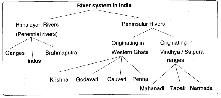
Explain the Himalayan river systems?
Answer:
Himalayan River Systems
The Indus system, the G.anga system and the Brahmaputra system come under the Himalayan river systems:
The Indus System: The Indus originates in Kailash range near Manasarovar. It enters Indian territory in Jammu and Kashmir. The Ravi, the Jhelum, the Ctienab, the Beas, and the Sutlej are its tributaries.
The Ganga System: The Ganga is formed joining Bhagirathl with Alakananda which join at Devaprayag. It has large number of tributaries.
The Brahmaputra System: The Brahmaputra is from Kalasli range near Manasarovar. It covers Tìbet and joins Arunachal Pradesh in India. It has different names in different places and is known as the Brahmaputra. The Dibang and the Lohit are its tributaries
Question 5.
Read the following paragraph and interpret it.
The socio-economic aspects are very important for water use management. Conflicts within communities in a region and across sectors such as use for agriculture, industry or drinking water are common?
Answer:
The ven paragraph describes the importance of water use management. In water use management there are so many conflicts. Those conflicts are not only between the regions but also in between sectors. Some conflicts are there with regard to drinking water also. Basically, water is a natural resource
All living creatures depend on water for their life. Human beings exploit water and they use more than they need. Water Is mainly used for various purposes like agriculture, industry, domestic purpose, cleaning of vehicles, floor cleaning, washing of clothes, and so on. The usage of water is not equal. Some rich people use more water whereas the poor have less access of water
There are so many reasons for variation in water use. In some states, water is used more for cultivation. In some regions, paddy is more and it needs more water. If dry land agriculture is followed, then less water Is enough. Sometimes they need more water depending upon the cropping. Some states have allegations and many court cases are there in pending about their water share. With regard to Tungabhadra water there is a
the conflict between Aridhra
Telangana and Karnataka states. Cauvery conflict is there in southernmost states Even in Telangana before its formation 5eparately. there was a movement on water share. For example, Andhra people used more water from both the Krishna and the Godavari rivers. In comparison to Northern states, the conflicts are more in south. In rural areas In Telangana, many tribal people suffer for pure drinking water
Government should implement the existing laws keeping the needs of all people irrespective of region. All people should have aooss to have pure water. Water for industries should be less and for agriculture more. Awareness programmes are to be organized by the District and Mandai authorities to make the people know about the importance of water. Water harvesting pits and check dams are constructed more. No water drop is to be wasted If all regions have access to sufficient drinking water and groundwater, there will be no conflicts
Question 6.
Read the given paragraph and write your opinion.
Regulation is not easy. This is also because for some resources like water, electricity, oil, natural gas, etc. consumption by one person or a sector affects what is available for others. in fact, in a number of states, the answer to tailing water tables has not been to address the issue itself. State governments have thus often chosen to increase power subsidies to make extraction of ever deeper layers of groundwater possible?
Answer:The given paragraph says that the regulation of natural resources like water, natural gas, etc. is not easy. Gradually water table is decreasing. Governments increase power subsidies to make extraction of ever deeper layers of groundwater possible
My interpretation is that water, electricity, oil, and natural gas are essential for all people. These are to be used in control. Whatever we use should be useful to the next coming generation. Natural resources are sustainable.
They can be useful to all generations. Water is an essential commodity. It is the people who decide the future. For a few decades, we have been observing that more groundwater is being pumped out
Sinking water is gradually decreasing. In forests also water is not available. So monkeys, and leopards are coming to villages. Deforestation is increased. Quarrying is also increased. Clouds are coming but they are not giving rain. Terrorature is increasing day by day. People should understand the need of the future and act accordingly. Per-head consumption is increasing drastically
Water conservation is an essential one. Not only human beings, birds, animals, plants also depend on water. Water harvesting pits are promoted at every house. Watershed programmes are to be taken up. Every drop of water should be caught perfectly and saved with proper proposals. Government concentrates on conservation of water to make next corning generation happy
Question 7.
What do you know about the peninsular rivers?
Answer:
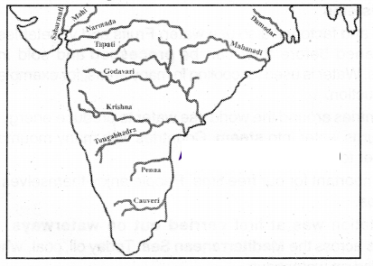
The Western Ghats are the water divide between the major peninsular rivers, discharging their water in the Bay of Bengal and as small rivulets joining the Arabian See. Most of the major Peninsular Rivers except Narmada and Tapati flow from west to east. The Chambal, Sind, Betwa. Ken and Son, originating in the northern part of the peninsular belong to the Ganga river system.
The other major river systems of the peninsular drainage are the Mahanadi, the Godavari, the Krishna, and the Cauverl. Peninsular rivers are characterized by fixed courses, absence of meanders, and largely non-perennial flow of water
Question 8.
Explain evapotranspiration?
Answer:
Evaporation, the turning of water into vapour, takes place all the time in water bodies. It can happen to any exposed surface water such as lakes, flyers, seas, etc. Living things also give off water into the atmosphere through their breathing process. This is callad trarispration. The total amount of water added to the atmosphere from both evaporation and transpiration is called evapotranspiration
Question 9.
Describe the Tungabhadra Basin?
Answer:
Tungabhadra, shared by the two southern states of Karnataka, Telangana and Andhra Pradesh, is a tributary of the larger river system Krishna. It originates in the Western Ghats with a catchment area of 71,417 km2, of which 57,671 km2 are in Karnataka
The Tungabhadra basin has two parts:
- the upper and middle catchments In Karnataka, and
- the lower portion of the catchment, In Telangana and Andhra Pradesh
Question 10.
Read the following paragraph and write your comments.
During the last two decades, there has been an increasing trend in the number of small towns and industrial areas. This has made the competing demands for water more complex. While increased industrialization and growth of urban areas have improved standards of living for some, the same activities have caused pollution, especially by industrial units?
Answer:
According to the given paragraph, it is clear that urbanization leads to water problems. Another point is that some people are leading prosperous life whereas many poor people are facing the problems of pollution. This is the two sides of a coin
In my opinion, in this modern age urbanization has become mandatory. People (torn villages are coming to cities and towns for different reasons. Employment, education for children, medical facilities, and different livelihoods are the needs of the rural people. As they come to cities and towns they face the problems of basic need like food, water, shelter, and cloth. All these are not available at fare prices. The fruits of urbanization
industrialization, and modernization are not equally distributed among the people. Some people especially rich are enjoying whereas the poor people are facing troubles in getting protected water
In conclusion, I dont say that urbanization Is not necessary but the problems of the poor migrants also should be considered. At industries and working sites water facility is to be provided. In all the areas protected water supply is necessary. Improving the standards of life of a few is not the goal of the government but it should take care of all people
Question 11.
Read the following paragraph and write your comment on it.
Over the past few decades, groundwater has become the main source of water, especially for domestic use and agriculture. The tremendous Increase in the use of groundwater has significant impact on water availability and access to It?
Answer:
According to this paragraph, the groundwater level is the crucial one to all the people. The groundwater is useful for both domestic purpose and for agriculture. If groundwater is not available, there will be many problems
My opinion is that because of modernization of agriculture motor pumps of high horsepower are being used. Very deep bore wells cause or drawing out water from the ground. Water has become a source of business many multinational companies draw water and sell in the form of bottles. Water conservation is also a major issue and Ills taken as a serious one
Every individual should think about the importance of water as it is useful to all people. Actually, once It was the common property. Now it has become individual property. Hence everyone should give importance to water. Otherwise, no one can get water
Question 12.
Read the following paragraph and comment on it.
Current laws on groundwater use are inappropriate because the basic links between access to groundwater and land ownership on which these rules are based are flawed. Since groundwater has to be extracted from the land above, a link was established between land ownership and control?
Answer:
The given paragraph says that the current laws aro not appropriate and there is no link between accesses to groundwater and land ownership. Proper laws are to be made and implemented otherwise there will be a mass problem of water.
I would like to comment on this paragraph that current laws are not being in elemented in a right way. The government should have true spirit of implementation of laws. There are so many laws rriade In the time of the British rule. After independence, these would have been modified or changed according to the present needs or new laws according to the situations and necessities have to be made time to time
This was not done. So the rich people or landowners are utilizing the water for the sake of themselves and the poor are not getting water. The water is an essential and primary good to everyone.
The government should take necessary action lo bring in new laws and they should be implemented in a right way. Discrimination between the rich and poor should be removed, Everyone should be treated equally
Question 13.
People are facing the problem of water scarcity In all the areas. It may be there in your locality also. Write a note on the condition of water scarcity that you recently observed?
Answer:
Scarcity of water has become the common problem everywhere. People of all corners are facing the same problem. They purchase even two glasses of water by paying twenty or twenty-five rupees. Though waler is available in some regions, it is not protected water.
Human activities like deforestation, using plastic, cement, and concrete roads are a few reasons for depletion of groundwater levels, Deforestation leads to low rain taU. Rain water is not percolated property because of iwo reasons
The first one is that the human beings are using plastic and after using it, It forms a layer on the earth. The other one is that they are covering the surface of the earth with coal tar and cement in the name of roads.
If rainwater doesnt percolate, there will be no groundwater. The power pune sets draw water out of the deep wells and bore wells and so it leads to depletion of groundwater level. The human beings are cutting down the halls and boulders in quarries. The tank water is also polluted by chemical effluents coming from industries. All these activities affect the human life in return
Other reasons are also there but these play a vital role. Water is basically a common property. The poor people also can be able to get drinking water. Deep bore wells should not be encouraged. By constructing small check dams, It Is better to store the water and so it could be useful to restore the groundwater. Then it will be expected that drinking water is available
Question 14.
Observe the following and answer the given questions?
Question1. Name some Himalayan rivers?
Answer:
The Ganga, the Brahmaputra and the Indus
Question2. Name some peninsular rivers?
Answer:
The Godavari and the Mahanadi
Question3. The Krishna river originates in ..........?
Answer:
Western Ghats
Question4. The Namada originates in ....... ranges?
Answer:
Satpura/Vindhya
Question5. Which rivers are known as perennial rivers?
Answer:
The Himalayan rivers are known as perennial rivers
Question 15.
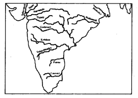
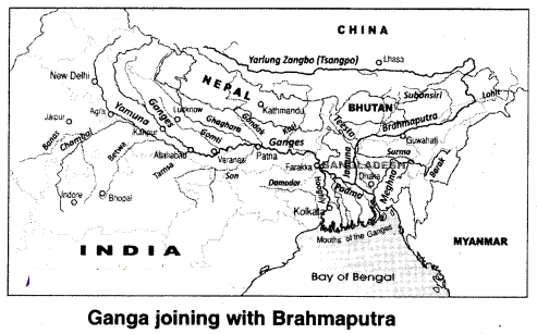 Observe the above map and answer the following?
Question1. Name the tributaries which are originated in peninsular plateau that joins the with Ganges?
Answer:
Tributaries onginated n the peninsular plateau and flowing towards the Ganges are Chambal, Betwa. Ken and Son, etc
Question2. Name the tributaries which are originated in Himalayas and joins with the Ganges?
Answer:
Tributaries originated wi the Himalayas and flowing towards the Ganges are Kosi, Gandak, Ghaghra, Gomati. Yamuna, etc
Question3. What is the name of the Ganges in Bangladesh?
Answer:
The name of the Ganges in Bangladesh is Padma
Question4. Which states share the drainage of Ganges?
Answer:
The drainage of Ganges is shared by the states Uttarakhand, Uttar Pradesh. Bihar, West Bengal Jharlçhand. Madhya Pradesh, etc
Question5. What is the name of the Brahmaputra in Tibet?
Answer:
The name of Brahmaputra in TIbet is Tsangpo
Question6. Mention any two tributaries of river Ganga?
Answer:
Gandak, Ghagra, Gornati, Son, Betwa, Chambal, Yamuna are the tributaries of river Ganga. (Any two can be written)
Question7. River Brahmaputra joins a river before joining into Bay of Bengal. What is the name of the river?
Answer:
The river m which the Brahmaputra, coins is the Ganga
Question8. Two countries are sharing the waler of the river Teesta. What are the two countries?
Answer:
India and Bangladesh
Question9. Which river is called Padma in Bangladesh?
Answer:
River Ganga
Question 16.
Create a poster on water importance?
Answer:
WATER IS LIFE
Water has been important for people for thousands of years. Without water there would be no life on earth. We use water in our houses for cooking, bathing and washing the dishes. Water is used to grow food. In many dry areas farmers must bring water to the fields through canals and expensive Irrigation systems
Industries and factories also use water. Fruits and vegetables must be cleaned before they can be processed and sold in supermarkets. Water is used for cooling m many areas, for example in steel production.
Many countries around the world use water to produce energy. Power stations burn coal which turns water into steam. Countries with many mountains and rivers use the power of water to produce electricity Water is important for our free time. People enjoy themselves at seaside resorts or on cruise trips
Transportation was at first carried out on waterways. Ancient civilizations traded goods across the Mediterranean Sea. Today oil, coal, wheat, and other products are transported on waterways
Question 17.
Read the following map and answer the questions?
Question1. Name the two mountain ranges that are suitable fer the origin of rivers?
Answer:
Mountains that are suitable for the origin of rivers are the Himalayas and the western ghats
Question2. Name the rivers which are originated in western ghats and Bowing towards East?
Answer:
Rivers originated in the western ghats and flowing towards east are Krishna, Godavari and Cauverl, etc
Question3. Name the west-flowing rivers?
Answer:
The west-flowing rivers are Narmacia and Tapati
Question4. List out the tributaries to the River Indus?
Answer:
The tributaries of indus are Jhelum. Chenab, Ravi, Sutlej, and Beas
Question 18.
Locate the names of the following Indian Peninsular Rivers. Sabarmati. Mahi, Narmada, Tapati. Damodar, Mahanadi, Godavari, Krishna, Panna, Cauveri?
Answer:
Question 19.
In which place has the water level gone down In your area? What are the reasons for the reduction of water levels according to your opinion?
Answer:
The water level gone down in many of our areas. The groundwater is useful for both domestic purpose and for agriculture. If groundwater is not available there will be many problems.
My opinion is that because of modernization of agriculture motor pumps of high horsepower are being used. Very deep bore walls cause for drawing out water from the ground. Water has become a source of business many Multinational companies draw water and sell the form of bottles. Water conservation is also a major issue and it is taken as a serious one
Question 20.
Recall from your science lessons what happens to the water that plants draw through their roots?
Answer:
- Plant absorbs water from the soil
- The plant combines water and carbon dioxide with the help of sunlight lo produce carbohydrates
- Starch, sugars, cellulose are also carbohydrates
- The plant does not use all the water it absorbs through its roots to produce carbohydrates, most of it evaporates into the air
- The water that plants release into atmosphere is called transpiration
- Most of the water released by plants evaporates from the leaves, which have microscopic holes called stomata
Question 21.
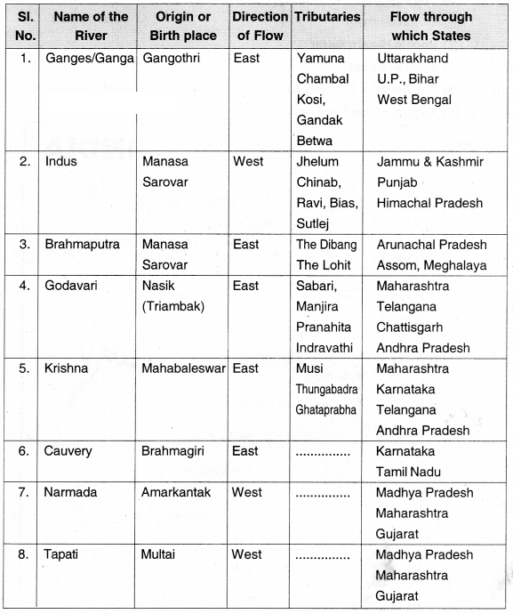
Explain any four river systems of india In the prescribed table form.
 ?
?
Answer:
Question 22.
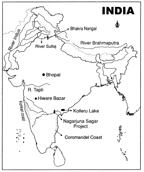
Locate the following in the given map of India?
- Brahmaputra river
- Drainage area of Indus river
- Nagarjuna Segar Dam
- The project on Sutlej river
Answer:
Bhakra Narigal
Question5. The river which l parallel to river Narmada?
Answer:
Tapti
Question6. The lake which In between Krishna and Godavari rivers?
Answer:
Kolleru
Question7. The coast of Tamil Nadu?
Answer:
Coromandel
Question8. Capital of Madhya Pradesh?
Answer:
Bhopal