TS 10th Class Social Important Questions 1st Lesson India: Relief Features
1 Marks Questions
Question 1.
What is the time in India when it is 8 am in London?
Answer:
1.30 pm in India when it is 8 am in London
Question 2.
Give examples for Himalayan hill stations?
Answer:
Examples for the Himalayan hill stations are
- Shimla
- Mussuone
- Ranikhet
- Nainital
Question 3.
Read the map given and answer the questions.
Question (a) Name the latitude that divides India into two parts?
Answer:
Tropic of Cancer / 23°30 Northern latitude
Question(b) On which longitude, is Indian Standard Time based upon?
Answer:
82°30 Eastem longitude
Question 4.
Mention any one difference between the physical features of the Andaman and Nicobar islands and the Lakshadweep?
Answer:
| Andamen and Nicobar Islands |
Lakshadweep Islands |
| Stretched in Bay of Bengal |
Stretched in Arabian sea |
| Some of these are of volcanic origin. |
These are of coral origin |
Question 5.
How are the Naricondam and Barren islands formed?
Answer:
The Narkondam and Barren islands are formed due to volcanoes
Question 6.
Why are the Peninsular rivers non-perennial?
Answer:
Peninsular rivers are non-perennial because they do not flow throughout the year
Question 7.
Differentiate Eastern ghats and Western ghats?
(OR)
Mention any two differences between the Western and Eastern Ghats.
Answer:
| Eastern ghats |
Western ghats |
| Less height |
More height |
| Not continuous ranges |
Continuous ranges |
| No origin of rivers |
Rivers originate |
| Highest peak is Aroma Konda |
Highest peak is Anaimudi |
Question 8.
Which continents 01 today were part al the Gondwena land?
Answer:
India, South Africa, Australia and South America were pail of the Gondwana land
Question 9.
Name three major divisions of the Himalayas from North to South?
Answer:
- The Greater Himalayas or Himadri
- The Meddle or Lower or Himachal Himalayas
- The Shiwaliks or Outer Himalayas
Question 10.
Name the island group of India having coral origin?
Answer:
Lakshadweep.
Question 11.
What is the peninsular plateau composed of?
Answer:
The peninsular plateau is composed of igneous and metamorphic rocks
Question 12.
Identify the regional division of the Northern plains?
Answer:
- Punjab plain
- Ganga plain
- Brahmaputra plain
Question 13.
What are the relief features that em found In the Northern plains?
Answer:
- Bhabar
- Terai
- Bhangar
- khadar
Question 14.
Which landforms feature was a part of Gondwana lend?
Answer:
Pensdar Plateau
Question 15.
Which plateau lies between the Aravalis and the Vindhya range?
Answer:
Matwa Plateau
Question 16.
Where are the Aravaft hills located?
Answer:
The Aravali hills are located on the western and north-western margins of the peninsular plateau in Rajasthan
Question 17.
What is a doab?
Answer:
The Land between two rivers is known as doab. Do means two, and means water
Question 18.
What is Bhangar?
Answer:
Bhangar is the largest part of the northern plains and is formed by the oldest alluvium
Question 19.
What is Khadar?
Answer:
The younger alluvium deposit is called Khedar
Question 20.
What is a reef?
Answer:
A ridge of jagged rock formed from coral secretions and skeletons
Question 21.
Name some kinds of reefs?
Answer:
Barrier reef, coral reef, and fringing reef
Question 22.
What was called Angara land?
Answer:
The northern part of Pangaea was called Angara land
Question 23.
What are known as Purvanchal?
Answer:
The Himalayas in the northeastem states are known as the Purvanchal hills
Question 24.
What Is the average altitude of Himadri?
Answer:
6,100 metres
Question 25.
Where is the Kanchenjunga peak?
Answer:
The Kanchenjunga peak is in Sikkim
Question 26.
Which is the second-highest peak in the Himalayas?
Answer:
K2, in the Karakoram range, is the second-highest peak after Mount Everest
Question 27.
Name the valley. In the Himachal rang?
Answer:
Kangra, Kulu, and Kashmir valley
Question 28.
What are Duns?
Answer:
The longitudinal valleys between the Lower Himalayas and the Shiwaliks are known as Duns. e.g.: Dehradun, Patti dun, Kotil dun
Question 29.
Where is Bhabar located?
Answer:
Bhabar is located at the toot of the Shiwaliks
Question 30.
What are the two divisions In the Peninsular Plateau?
Answer:
Central Highlands and Deccan Plateau
Question 31.
Which is the easternmost part of the central highlands?
Answer:
The Chotanagapur Plateau is the easternmost part of the central highlands
Question 32.
Which is the highest peak in the western ghats?
Answer:
Anaimudi
Question 33.
What is the other name of Ooty?
Answer:
Udagamandalam
Question 34.
Which is a narrow coastal plain?
Answer:
The Western coastal plain is a narrow plan
Question 35.
Name the Peninsular rivers?
Answer:
The Godavari, the Krishna and the Cauvery
Question 36.
According to the given table below, which area is the eastern side?
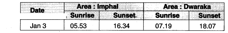
Answer:
According to the given table, Imphal is located on the east side
Question 37.
Which Indian Islands are Volcanic Origin?
Answer:
Andaman and Nicobar. (OB) Narkondam and Barren
2 Marks Questions
Question 1.
Mention the major relief divisions of Indian landmass?
Answer:
The relief divisions of Indian landmass can be divided into following groups:
- The Himalayas
- The Indo-Gangetic Plain
- The Peninsular Plateau
- The Coastal Plains
- The Desert
- The Islands
Question 2.
Why are the Himalayas important to India?
Answer:
- The formation of the Himalayas influences the climate in various ways
- These act as barriers protecting the great plains of India from the cold winds of central Asia during severe winter
- The Himalayas are reason for summer rains and monsoon-type climate in regions that are beyond the Western Ghats of India
- The Himalayan rivers have a perennial flow since these are fed by the glaciers
- These rivers bring a lot of silt, making these plains very fertile
- There are famous hill stations like SimIa, Mussorie, Nainital, Ranikhet, etc. covered by evergreen forests
- The valleys are known for the cultivation of fruits
- There are passes in the Himalayas which act as great exchange of culture and commerce
Question 3.
How are the Himalayas divided regionally or on the basis of river valleys?
Answer:
- Punjab Himalayas between rivers Indus and Sutlej
- Kumaon Himalayas between rivers Sutlej and Kali
- Nepal Himalayas between rivers Kali and Teesta
- Assom Himalayas between n vers Teesta and Brahmaputr
Question 4.
Look at the picture and comment on It?
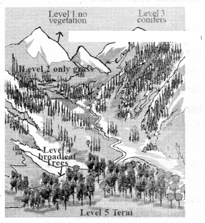
Answer:
It is a sketch of different levels of vegetation In the Himalayas. There are 5 levels in that
vegetation.
Level I: On the top of the mountains - there is no vegetation.
Level II: On the hill slopes - there is only grass.
Level III: Next to the level II - this area is covered with conifers.
Level IV: Next to level III - this area is covered with broad-leaf trees.
Level V: At the feet of the mountains. It is Terai with tree cover
Question 5.
Write a short note on the Great India n Desert?
Answer:
The Great Indian Desert lies towards the western margins of the Aravalli Hills. The region gets scanty rainfall. Hence the climate is arid and vegetation is scanty. Luni is the only large river. Some streams appear during rainy season. Crescent-shaped dunes are formed around in this area
Question 6.
Discuss the various islands in India?
Answer:
- There are 2 groups of islands - Andaman and Nicobar Islands stretched in Bay of Bengal and Lakshadweep Islands in the Arabian Sea
- In Andaman and Nicobar Islands, Narkondam and Barren islands are volcanic origin
- The southernmost tip of India found in Nicobar island called Indira Point which was submerged during the 2004 Tsunami
- Lakshadweep Islands are of coral origin
- It is famous for great variety of flora and fauna
4 Marks Questions
Question 1.
Classify the Indo - Gangetic plain and explain?
Answer:
Classification of the Indo-Gangelic Plains
- The Western part
- The Central part
- The Eastern part
Explanation:
Western part: Formed by the Indus and its tributaries, the Jhelum. the Chenab, the Ravi, the Beas and the Sutlej
- Major portion of the plain Is located in Pakistan and minor portion In Punjab and Haryana
- Doab features dominate the fertile land between the two rivers
Central part:
- Known as Ganga Plain
- Extends from the rivers Ghaggar lo Teesta
- Spread the States of Uttar Pradesh, Bihar, and parity in Haryana. Jharkhand and West Bengal
- River Ganga. Yamuna and their tributaries Sone, Kosi drain
Eastern part:
- Exists mostly In the Brahmaputra Valley of Assam
- Fomied by the river Brahmaputra
Question 2.
Read the following paragraph and comment on Indian climate and the Himalayas.
The formation of the HWnalayas influences the climate in various ways These act as barriers protecting the great plains of India (Toni the cold winds of central Asia during severe winter. The Himalayas are the reason for summer rains and monsoon-type climate In regions that are beyond the Western Ghats of India. In its absence, this region would have remained drier?
Answer:
According to the paragraph given, it is clearly understood that the Himalayas are useful to India in many ways. It means that because of the Himalayas only there are fertile soils, sufficient rainfall, and perennial rivers and so it is useful to agriculture which is the backbone of our economy. I agree with this paragraph because every point discussed here is correct.
The Himalayas are extending in the north of our country from Jammu Kashmir to Arunachal Pradesh for about 2400 kilometers. Automatically they stop the cold winds blowing from central Asia because our cultivable lands are in the south
If the Himalayas were not there, India would become dry land or a desert. In the name of modem life, we are cutting down the trees which lead to low rainfall and polluting river water. In every country there may be a few natural resources which are helpful to the country.
The people should utilize the natural resources by keeping the future needs of the next coming generations. Otherwise, the resources will not be accessible for them: Though we have many benefits from the Himalayas, the passes of the Himalayas caused for foreigners to Invade our country and these helped in exchanging business and culture
Question 3.
In what ways Is the Indo-Gengetic plain different from the Peninsular plateau?
Answer:
| Indo - Gangetlc plain |
Peninsular plateau |
| 1) This plain area was formed due to deposition of sediments brought by rivers |
1) Plateau region was formed due to volcanic eruption |
| 2) It consists of alluvial soil |
2) It is mainly composed of the old crystalline, hard igneous rocks and metamorphic rocks |
| 3) It has fertile alluvial soils and flat surface |
3) It has rugged surface |
| 4) It provides much irrigation facilities |
4) It also provides much irrigation facilities |
| 5) Plain regions have perennial rivers |
5) Plateau region does not have any perennial river |
| 6) Plains are rich in agriculture practice |
6) Plateau region is rich in mineral resources |
Question 4.
How can you say that India has a long coastal line?
Answer:
- The southern part of the peninsular plateau is bordered by narrow coastal strips along the Arabian Sea on the west and the Bay of Bengal on the east
- The western plain is uneven and broken by hilly terrain
- It is divided into 3 parts. 1) Konkan coast-northern part comprising Maharaslitra and Goa coast
- The second is Canara Coast - the middle part includes coastal plain of Karnataka
- The last part Is Malabar coast the southern part, mostly in the state of Kerala
- Bay of Bengal plains are wide and have large surface structure
- It stretches from Mahanadi in Odisha to Cauvery deltas in Tamil Nadu
- These coastal plains are known locally by different names as Utkal coast in Odisha, Sircar coast In Andhra Pradesh and Coromandel coast in Tamil Nadu
Question 5.
Describe the various aspects of the peninsular plateau?
Answer:
- The Indian Plateau is also known as the peninsular plateau as it is surrounded by the sea on three sides
- Large amounts of metallic and non-metallic mineral resources are found here
- Its topography is slightly tilted towards east
- its two divisions are central islands (Malwa plateau) and the Deccan Plateau
- The rivers here are not perennial
- The triangular landmass to the south of Narmada ¡s called Deccan Plateau
- The structure of Western Ghats is continuous with a few passes as the gateways lo the coastal plains
- The Eastern Ghats are not continuous
- One of the remarkable features of the peninsular plateau is black soils formed due to volcanic actvity
Question 6.
Write about the Middle or Lower or Himachal Himalayas?
Answer:
- The mountain range which runs parallel between the Shiwaliks in the south and the Great Himalaya In north Is classified as the Middle Himalaya, sometimes also called Himachal or Lower Himalaya
- It has an intricate system of ranges which are 60-80 km wide having elevations varying from 3,500 to 4.500 mt above sea level
- Many peaks are more than 5,050 mt above sea level and are covered with snow throughout the year
- Pir Parijal. the Dhaola Dhar, the Mussoorle Range. the Nag Tiba and Mahabharata Lekh are some of the important ranges of the Middle Himalayas
- The Pir Panjal, southernmost range of the Middle Himalayas, In the Kashrnlr Is the longest and the most important range
- The Mussoorie Range has an average elevation of 2000-2.600 m and runs over a distance of 120 km from Mussoorie to Lansdowne
Question 7.
Write about the Thar desert?
Answer:
- The Thar Desert is located on the leeward side of Aravalis and receives very low rainfall, ranging from 100 to 150 mm per year
- The desert consists of an undulating sandy plain and rocky outcrops
- It occupies much of western Rajasthan
- It has an arid climate with very low vegetation cover
- Streams appear during rainy season and disappear soon after
- Luni is the only river in this area
- The internal drainage rivers fall into the lakes and dont reach the sea
- Indira Gandhi canal is watering part of Thar desert
- Several hectares of desert land have been brought under cultivation
Question 8.
Read the following paragraph and interpret.
It is important to note that IS vast diversity In the landforms in which Indian people live. Some areas are irrigated by the mighty rivers flowing from the Himalayas and some by the rain ad rivers from Western ghats and its forests. Many places are located the river valleys and others in the mountains?
Answer:
The given paragraph is about diversity In India. There is a lot of vacation with regard to irrigation facilities. Some regions have well-irrigated lands whereas it ¡s not possible in many regions.
This variation is because of rivers and mountains. Where rivers are more, projects can be built and stored water is used for cultivation. It is not possible in regions Like Northeast states. Hilly and rocky areas have no such scope though they have good rainfall. Rain shadow regions also have the same experience. These variations reflect the livelihoods also. Coastal people have different livelihoods in corNansofl to the livelihoods of continental areas.
The Govt. should consider the rebel features and provide opportunities accordingly. People also should change their conventional activities and adapt according to the needs and conditions
Question 9.
Read the following paragraph and write your opinion on the condition of the area as well as people living there.
Desert is located on the leeward side of Aravalis and receives very little rainfall, ranging from 100 to 150 mm per year. The desert consists of an undulating sandy plain and rocky outcrops. It occupies much of western Rajasthan. It has an arid china with very low vegetation cover. Streams appear during rainy season and disappear soon after. Luni is the only river in this area. These internal drainage rivers till into lakes and do not reach the sea?
Answer:
This paragraph says that much of western Rajasthan Is sandy and without adequate rainfall. Without sufficient rainfall, we cant expect proper cultivation and production of lamps. Though Rajasthan ranks first in the area it has maximum desert area. According to this paragraph, there are a few streams which can be seen during rainy season. The unfortunate thing of the people living there Is that the area is in the leeward side of the
Aravali Mountains
The southwest monsoons remain empty by reaching there. My opinion Is that the people should make a few changes in their livelihoods. They should grow more crops during rainy season. It would be better for them to go for multiple cropping. They grow food crops with the help of Indira Gandhi canal water irrigation. Government should provide their cory oddities at subsidized prices. Along with the Indira Gandhi canal, there should be many more schemes like that till their needs are fulfilled
Question 10.
Read the following paragraph and write your opinion on the geographical location of India.
The geographical location of India provides Its vast diverse climatic conditions. This has led to a variety of vegetation and life forms along with advantages for growing many kinds of crops. Its king coast hue and location in the Indian Ocean enable trade routes as well as fishing?
Answer:
According to this paragraph, the geographical location of India Is very prosperous. India has ocean water on the three sides where as the high Himalayan Mountains in the north. These Himalayas give birth to various perennial rivers because of glaciers so as to grow more crops and this led to variety of vegetation
In my opinion, there are a few benefits as well as losses to the people living in coastal plains and hilly areas. The coastal people face some drastic situations when there is a tsunami or cydones. The people living in hilly areas face the problem of landslides. Nowadays global warming is increasing, It may lead to submerge of coastal cultivable lands.
The people may face many problems.
Along with these problems they have the opportunity of maintaining foreign trade with the help of sea routes. Visakhapatnam, Chennai, Mumbai and Cochin are some of the examples for the trade centers of see routes
Question 11.
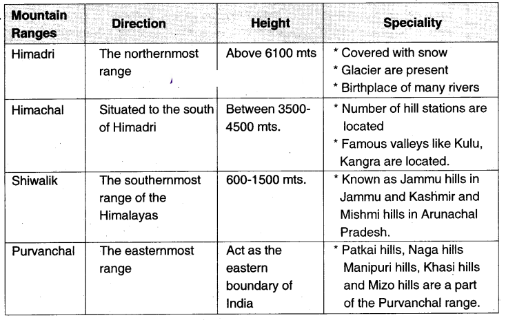
Observe the table and answer the following questions?
| Name of the range |
Average height |
Special features |
| 1. The Greater Himalayas |
6100 mts |
Composed of ice and snow cover. Glaciers are found |
| 2. The Middle or Lower or Himachal Himalayas |
3500 lo 4500 mts |
Composed of highly compressed or rocks. Pit panjal. Mahabharata; ranges are there. Famous for hill stations |
| 3. The Shiwaliks |
600 to 1500 mts |
Different names in different regions |
Question1.
What are the names of the three Himalayan ranges?
Answer:
The three names of the Himalayan ranges are the Greater Himalayas, the Middle or
lower or Himachal Himalayas and the Shiwallis
Question2.
Which of the ranges have hill stations?
Answer:
The hilt stations are found in the lesser Himalayan ranges
Question3.
Where do we find Dehra Dun and Path Dun?
Answer:
We find Dehra Dun and Path Dun in the valleys In between the Lower Himalayas and the Shwahks
Question4.
What is the difference in between ta. ranges of the Greater Himalayas and the Lower Himalayas with regard to the composition?
Answer:
The Greater Himalayas are composed of ice and snow cover whereas the Lower Himalayas are composed of highly compressed rocks
Question 12.
Prepare a table showing the particulars of different mountain ranges of the Himalayas?
Answer:
Question 13.
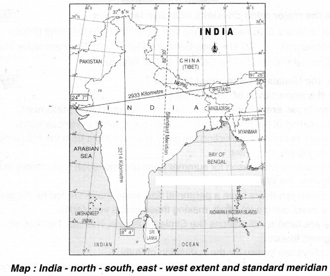
Read the given map and answer the following questions?
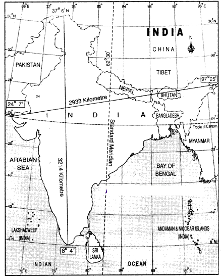
Question1. What is the standard meridian in Iixa?
Answer:
82°30 Eastern Longitude is the standard mendian In India
Question2. Name the latitude that moves from the centre of India?
Answer:
23½ northern latitude moves from the centre of India. Ths Is called as Tropic of Cancer
Question3. What is the distance between north and south tip of India?
Answer:
The distance between north and south tips is 3214 kms
Question4. Mention the location of India?
Answer:
India is located in between the latitudes cf 8° 4 and 37° 6 N and longitudes of 68° 7 and 97° 25 E
Question5. Name any two frontier countries of India?
Answer:
Pakistan, China, Bhutan. Myanmar. Bangladesh and Nepal. (Any two can be written)
Question6. Which Islands are located In the southeast corner of India?
Answer:
Andaman Nicobar Islands are located in the southeast corner of India
Question 14.
Read the given map and answer the following questions.
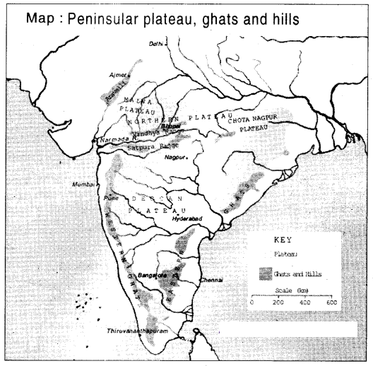 ?
?
Question1. Which river flows westwards?
Answer:The river which flows toward is Narmada. (Tapti also)
Question2. Which plateau is there on the leeward side of the Aravali?
Answer:
Malwa plateau is there on the leeward side of the Aravali
Question3. Where do the eastern and western Ghats join?
Answer:
The eastern and western Ghats join Nilgirts near Gudalur
Question4. Which ocean is located in the south of India?
Answer:
The Indian Ocean is located in the south of India
Question5. Which plateau Is there in between Malwa and Chota Nagpur plateaus?
Answer:
Central plateau Is there in between Maiwa and Chota Nagpur plateaus
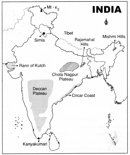
Question 15.
Locate the following In the gIven map of India?
Question1. Locate the Highest plateau in the world?
Answer:
Tibet
Question2. Capital of Himachal Pradesh?
Answer:
Simla
Question3. Highest peak in India?
Answer:
Mt-K2
Question4. Locate the Hills in Arunachal Pradesh?
Answer:
Mishmi Hills
Question5. This plateau has rich variety of mineral resources?
Answer:
Chotanagpur Plateau
Question6. Triangular plateau?
Answer:
Deccan Plateau
Question7. Southernmost tip of India?
Answer:
Kanya Kumari
Question8. Mashy Swampy region of Gujarat?
Answer:
Rann of Kutch